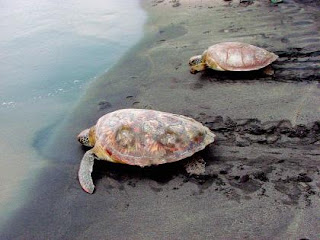
In last week’s post we learned about the mangrove forest in the Chiquimulilla Channel, which is part of the Monterrico-Hawaii Nature Reserve administered by the Center for Conservationist Studies. Today, I want you to join me to learn about some of the most fascinating creatures in the world: sea turtles.
Along the shoreline in the Pacific Ocean and throughout different countries, from times that no one can remember, year after year, several species of sea turtles return to the same place to lay their eggs in an amazing cycle of life, a cycle that is interrupted and threatened mainly by irresponsible human actions.
The good news are that there are those who care enough and not just understand the importance to preserve these wildlife cycles of life but most important, they are true hands-on heroes and guardians of the two largest hatchery projects:
Tortugario Monterrico, managed by the Center for Conservationist Studies and
Hawaii Park, located 8 kilometers east of Monterrico, where the Wildlife and Conservation Association, has a turtle, crocodile, and mangrove conservation project.
These hatcheries were born primarily as an attempt to counteract threats to Leather-back (also known as baula) and Olive ridley (also known as parlama) turtle populations by over-harvesting by local egg collectors.
Despite their endangered status, virtually all sea turtle nests in Guatemala are poached and the eggs sold as a supposed aphrodisiac; clearly not a necessity in the country since the population growth rate is of nearly 3%.
Both reserves, Monterrico and Hawaii are prime nesting sites for sea turtles on Guatemala’s Pacific seaboard, so chances are that if you are visiting the area between June and December, you might have the opportunity to witness either a big Leather-back or the smaller Olive ridley coming ashore to lay its eggs or watch baby sea turtles making their maiden voyage out to sea.
To simulate the emergence of the turtles from the nest, they are placed high up on the beach to let them scatter as they head towards the whiteness of the waves. As they scramble across the beach, they are collecting information that will enable them to come back to the very same beach spot in eight years time.
No one knows exactly what happens during this imprinting process, maybe they pick up the texture and composition of the sand, the smells on the beach, and the magnetic current which they use to navigate the oceans. But that two minutes will enable them to come back here when they are grown and lay on this exact same stretch of beach.
You can watch them scramble into the waves and then wait for a sufficiently powerful one to carry them off into the depths. Only very few will survive their passage through the breakers and predators. But a few are better than none.


